Using the GUI
In order to be available for a broader audience, a GUI is also provided. However, the GUI is not part of the pypi or conda package yet. You have to download it mannually from the git repo ( direct link ).
There are several way to run the GUI, depending on what you are familiar with.
- From the terminal: navigate where the
GUI.pywfile is, then enter
python3 GUI.pyw
- Using spyder/ipython
%run GUI.pyw
- Graphically: simply double click on
GUI.pyw. It may work. Maybe.
If it doesn’t start, ensure that you are running python 3 and not python 2.
Initialization
The script looks for files in parameters named localParamBackTraj.json,
localParamPSCF.json, locationStation.json.
The package gives you the same three file, with a _default.json extension.
Copy and rename them in order to have the correct one in parameters:
parameters
├── SETUP_backTraj.CFG
├── localParamBackTraj.json
├── localParamBackTraj_default.json
├── localParamPSCF.json
├── localParamPSCF_default.json
├── locationStation.json
└── locationStation_default.json
Compute the back-trajectories
Hysplit
The back-trajectories have to be computed before running the PSCF script. We use here the HYSPLIT program from the NOAA. As HYSPLIT is a relatively big software with many option and configuration, we developed a tool to compute the back trajectory in a easy way. However, you still need the HYSPLIT program. You can found it at http://ready.arl.noaa.gov/HYSPLIT.php.
GUI description
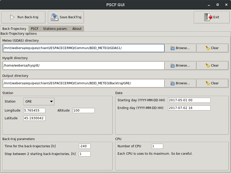
Once the script starts, you should see the window presented in the figure above.
Navigate to the Back-trajectory tab on the top if it is not already open.
This window presents the different parameters use to compute the back-trajectories.
Let’s describe each of its field.
- Button frame
- Run Back-traj: Save the parameters show in this tab in
parameters/localParamBackTraj.jsonthen compute the back-trajectories with theses parameters. - Save BackTraj: Save the parameters in the
parameters/localParamBackTraj.jsonfile without running the computation. - Exit: Quit the GUI without saving the parameters.
- Run Back-traj: Save the parameters show in this tab in
- Meteo (GDAS) directory: select the path to the GDAS files. GDAS is a file format uses to store meteorological data and are freely available from the NOAA website or ftp.
- Hysplit directory: select the root path of the Hysplit directory’s installation. It should contain the subdirectories working, exec, script etc.
- Output directory: select where the back-trajectories files will be save.
- Station frame
- Station: select the desired reference point. If the station is not in
the list you have to add yourself the station in the
parameters/locationStation.jsonfile. - Longitude/Latitude: enter the longitude/latitude of the station. It should be updated automatically with the selection of the station.
- Altitude: enter the altitude (in meter from the surface) of the back-trajectory starting point.
- Station: select the desired reference point. If the station is not in
the list you have to add yourself the station in the